Wednesday, June 24, 2015

Devil's Dome Loop

"...if this is Devil's Country, we need to start sinning" BarbE

The Devil's Dome Loop is a 42-ish-mile loop in the North Cascades of Washington, specifically on the western side of the expansive Pasayten Wilderness and along the eastern side of Ross Lake. The loop completes a circumnavigation of 9,066' Jack Mountain, traveling along high ridges and subalpine parks for approximately half its length and along Ross Lake and above Ruby Creek for its other half. The loop is fairly well known, well described, and well traveled, so I'll keep my own verbiage short.

The loop is almost exclusively done counter-clockwise, the prevailing wisdom being that this will allow you to get the bulk of the elevation gain done early and finish your day (or trip) with the relatively easy miles along Ross Lake and Ruby Creek. If you're attempting the loop in a day, traveling counter-clockwise will also help you spend the hottest part of the day under tree cover rather than on the exposed terrain of Jackita Ridge.

Descriptions of the route can be found at:


Trip reports and photos can be found at:


Distance: 42-ish miles

Elevation Gain: Approximately 11,000'

Maps and More:

Overview Map:


Trailhead: It's possible to begin this trip at either the East Bank Trailhead or the Canyon Creek Trailhead. Approximately 3 miles could be saved by setting up a shuttle between the two trailheads. Even more miles could be cut out by making use of a water taxi on Ross Lake to take you to Devils Junction.


Monday, June 15, 2015

I-90 Routes

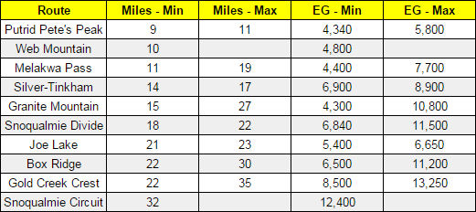
After exploring the nooks and crannies of I-90 between North Bend and Snoqualmie Pass for the last few years, I have some routes that I like. In general, they share a few characteristics: 1) they are loops; 2) most of them incorporate unofficial/abandoned trails or cross-country travel in order to connect official trails into more elegant routes; 3) they'll get you off the beaten path; and 4) they're absolutely worth doing. The 'Granite Mountain Circumnavigation' is an exception to some of these, being entirely on well-traveled trails and already being very well-known, but I've included it because it's popular and in the area.

THE ROUTES


"Miles - Min" and "EG - Min" refer to the loop itself with no side trips
"Miles - Max" and "EG - Max" include the loop and recommended side trips


If you try one of these routes and have general feedback, pictures I could use to help show off the routes, GPS data I can use to verify/increase the accuracy of what I've posted, or any other kind of comment, please don't hesitate to contact me through the form at the bottom of the page.

I'm putting this info "out there" with the hopes that it will encourage people to try something more challenging and interesting than yet another out-and-back to some lake or viewpoint, but I make no guarantees about the accuracy of anything posted here, the experience you'll have, or that I even necessarily have your best interests in mind. While all of the routes are "walkable" in that they do not require technical climbing or difficult scrambling, they will take you off well-maintained trails, require actual navigation skills, and are overall much more of "wilderness routes" at times than they are "just another day on trail". I encourage everyone to get outside their comfort zone and challenge themselves, but to do so safely and responsibly.

Snoqualmie Pass Circuit

By combining the Silver-Tinkham Loop, the Melakwa Pass Loop, and the Granite Mountain Circumnavigation you get... the Snoqualmie Pass Circuit: a 32-mile loop with over 12,000 feet of elevation gain that tours the Snoqualmie Pass area. The Circuit has views of over a dozen alpine lakes, travels directly over the summits of two peaks, and experiences everything from challenging off-trail travel and climbing a 1,000 vertical feet over talus to running the incomparably well-maintained Pacific Crest Trail.

Distance: Just over 32 miles

Elevation Gain: Around 12,000 feet

Maps and More:

Overview Map:

Thursday, June 11, 2015

Silver-Tinkham Loop

If you like bagging peaks and technical trails, this loop is for you. Easy approaches on the Annette Lake and Pacific Crest Trails disguise the core of this route: steep, barely-there trails that climb directly up peaks left and right, including a 2,000' vertical climb directly up the talus slopes of Silver Peak.

Distance: About 14 miles for the simplest route and closer to 17-18 with all recommended side trips

Elevation Gain: Nearly 7,000 for the simple route and nearly 9,000 feet with all side trips. It's a steep one.

Maps and More:

Overview Map:


Trailhead: https://goo.gl/maps/yLqqV


More information:
http://www.wta.org/go-hiking/hikes/annette-lake
http://www.hikingwithmybrother.com/2008/12/annette-lake-120708.html

http://www.summitpost.org/west-slope/223239
http://www.summitpost.org/abiel-peak/567364
http://www.summitpost.org/tinkham-peak/151401

Joe Lake Loop

Work your way up the Gold Creek Valley and then enjoy a smooth ride back along the PCT on this 21-mile loop. Getting from the Alaska Lake junction up to the PCT is a bit of a challenge, with steep brushy trails and a short chunk of cross-country, but totally worth doing for the elegance of tying this loop together. Alaska and Joe Lakes are rarely-visited gems and the views along the PCT are hard to beat.

Distance: 21 miles for loop alone and about 23 with the recommended sidetrips to Alaska Lake and Mountain

Elevation Gain: Around 5,500' feet of gain for the loop and 6,700' with both sidetrips

Maps and More:

Overview Map:


Trailhead: https://goo.gl/maps/ch7kj


The Alaska Lake junction

A waterfall just below Joe Lake

Looking up at the PCT from Joe Lake. The recommended cross-country path is 
through the brush and up the open slopes on the right side of the picture

Looking back down at Joe Lake from the PCT


More information:
http://www.wta.org/go-hiking/hikes/little-joe-lake

http://www.wta.org/go-hiking/hikes/gravel-lake

http://www.hikingwithmybrother.com/2010/07/gold-creek-trail-1314-to-alaska-lake.html
http://www.summitpost.org/alaska-mountain/516504

http://www.hikingwithmybrother.com/2009/08/kendall-katwalk-peak.html
http://www.wta.org/go-hiking/hikes/kendall-katwalk

Monday, June 8, 2015

Granite Mountain Circumnavigation

This loop seems to be the most popular run along I-90 and is known by many names, usually involving some combination of the lakes it visits, but I prefer to call it the 'Granite Mountain Circumnavigation'. As the loop leads you to waterfalls on Denny Creek, over two mountain passes, and past a handful of alpine lakes, one feature remains constant: its encirclement of the Granite Mountain "massif". If you have the extra time and energy, a sidetrip to the lookout-adorned summit of Granite Mountain is well worth the effort.

I recommend running the loop counterclockwise. The trail leading up to Melakwa Lake is rocky and slow, making it a much nicer ascent then descent, and the trail descending from Pratt Pass back to the Pratt Lake Trailhead is a wonderful stretch of trail that is best enjoyed as a downhill run.

Distance: About 15 miles for the loop itself (including the road miles) and as much as 27 if you do both sidetrips to Kaleetan Lake and Granite Mountain.

Elevation Gain: 4,300 feet of gain for just the loop, 7,400 if you include Granite Mountain, and close to 11,000 if you visit Kaleetan Lake and Granite Mountain.

Maps and More:

Overview Map:


Upstream from the waterslide

Keekwulee Falls

Upper Melakwa Lake


More information:

http://www.wta.org/go-hiking/hikes/denny-creek
http://www.wta.org/go-hiking/hikes/melakwa-lake
http://www.wta.org/go-hiking/hikes/pratt-lake
http://www.wta.org/go-hiking/hikes/granite-mountain-1

Tuesday, June 2, 2015

Webb Mountain Loop

Get off the beaten path on this short-but-tough loop that makes use of little known trails and cross-country travel to avoid the I-90 crowds.

I would only recommend this loop clockwise. Navigation (and traveling cross-country) will be easier going uphill towards Web Mountain, the views along Banana Ridge are better looking east, and the descent from Mount Defiance will be more runnable than the descent off Web Mountain if you went CCW.

Distance: About 10 miles, though it will feel like more due to the cross-country and navigation.

Elevation Gain: Around 4,800 feet

Maps and More:

Overview Map:


Stay right here, going left will return you to Exit 42

Continue straight, going right will lead to Putrid Pete's Peak

From Dirty Harry's Balcony

Turn right onto Dirty Harry's Peak Trail

The switchback to Dirty Harry's Peak goes left here, continue straight to Web Mountain

The small pond (Dirty Harry's Bathtub) at the top of the Granite Creek drainage

Looking back on part of the cross-country section to Web Mountain

Somewhere on the flanks of Web Mountain

The Putrid Pete's Peak Trail turnoff from Ira Spring

The Mason Creek Trail to Exit 42 drops off the right side of the road just before the boulder pile


Monday, June 1, 2015

Melakwa Pass Loop

Between Melakwa Lake and Gem Lake lies, in my opinion, the finest piece of cross-country travel near Snoqualmie Pass. You may have to fight through swarms of hikers in the first few miles leading up to Snow Lake and Denny Creek but it's worth it for the solitude, scenery, and off-trail rambling you'll find just beyond the crowds.

Having done this loop both clockwise and counterclockwise, I greatly prefer going CCW in large part because it makes navigation between Gem Lake and Melakwa Lake much easier. If done correctly, the cross-country section is not technical or particularly difficult. I would rate it Class 2, though definitely strong Class 2 with a few spots where you may use your hands for a little additional stability.

From Gem Lake, follow the evident climbers' trail shown on the maps until you reach a small talus field on the ridge, somewhere in the 5,300-5,400' elevation range, where you may see cairns or a faint boot path leaving the ridge and heading towards Chair Peak Lake. You should be just below one series of cliffs and a ways above another, on a moderate slope that provides good travel towards Chair Peak Lake. Use the upper cliff band as a handrail, staying below the cliffs and following them for a ways until the terrain begins to open and you can choose your route to Chair Peak Lake, and Melakwa Pass, by sight. You may find occasional patches of boot paths along the route but there is no consistent path and this is truly off-trail.

Distance: Right around 15 miles for the entire loop, but only 11 if you do a car shuttle between trailheads. Making the recommended side trips to Upper Wildcat Lakes and Wright Mountain will take you up to 19 miles.

Elevation Gain: 5,400' for the full loop and about 1,000' less if you do a shuttle. Approximately 7,700' for the loop and both side trips.

Maps and More:

Overview Map:


On the climbers' trail above Gem Lake

Overlooking Snow Lake from the cross-country section

Turn off the climbers' trail at this talus field. Follow the lower edge of the talus on a faint boot path then begin traveling cross-country to Melakwa Pass

Looking south down to Melakwa Lake

Looking north from Melakwa Pass

Looking back at Melakwa Pass with Chair Peak on the left

A rare view of Snow Lake

From Wright Mountain: Gem Lake in the lower left, Kaleetan Peak in the upper right


More information:
An alternate cross-country route description for early season with more snow coverage