The High Pass High Route is described on pages 112-114 in the classic text Routes and Rocks by D.F. Crowder and R.W. Tabor (well worth a look if you're unfamiliar) but more recent instructions can be found in this excellent NWHikers trip report. The "steep snow gully about 50 feet wide" immediately north of High Pass that's referenced in Routes and Rocks has historically been a route hazard that persisted through the summer and the prevailing wisdom was to always carry an ice axe when crossing High Pass. In more recent years, this snowfield has been melting out sometime in late summer and is of no concern at that point, though it may still merit carrying an ice axe earlier in the summer.
The climb to Little Giant Pass from the Napeequa Valley is a notoriously steep, rough, and brushy trail, though ascending it shouldn't pose any more of a problem to experienced travelers than High Pass does. I wouldn't recommend descending from Little Giant Pass to the Napeequa, though I have encountered people doing it and it can be done. In 2009, two horses fell to their deaths while descending from Little Giant Pass to the Napeequa Valley.
Distance: about 31 miles
Elevation Gain: 8,500-9,000'-ish
Maps and More:
- 1x31680 scale (1 inch = 0.5 mile) for the on trail portions and 1x24000 scale for off trail
- Mileage, elevation gain, and route details
Overview Map:
Trailhead:
Entering Glacier Peak Wilderness
Helmet Butte coming into view
Glacier Peak from near Buck Creek Pass
Glacier Peak and the Dakobed Range
Approaching High Pass
High Pass, the route goes across the slope on the left side
Triad Lake
Beginning the descent from High Pass to the Napeequa Valley
Muddy marmot tracks
Continuing the descent to the Napeequa Valley
Getting views of Clark Mountain and the eastern end of the Dakobed Range
Closer view of Clark Mountain
First look downstream the Napeequa Valley
Louis Creek
Clark Glacier up close
Looking back upstream along the Napeequa River
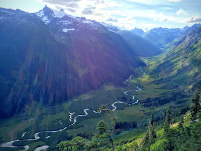
The Napeequa Valley: as pretty as an Alaskan glacial valley and almost as brushy
Beetle-killed trees (the brown stands) above the Chiwawa River valley
More info:
Luke's excellent trip report from October 2014


Great run! I'm looking at doing this trip as a two day in mid-late August this year. I've heard mixed reports about the west side of Little Giant Pass and the snowfield around High Pass. How are these sections? Is there anything else I need to be concerned about? Also, for splitting it up, I was thinking first day go up to Buck Creek Pass, through High Pass and camp in the upper Napeequa Valley around 5500 ft. Is that a good place to break it up? Thanks.
ReplyDeleteYour comment just encouraged me to add some more details that I've been meaning to write in (thanks!) so look above for that.
ReplyDeleteThe west side of the LGP is as described above: steep, rough, and brushy, but doable.
The snowfield near High Pass seems to be dying and was almost completely melted out by mid-July when I went through this year. Hard to say how late in the summer it will persist going forward but it seems to be melting out earlier than in the past.
The campsite at 5500' looks like a nice one and is in a good spot for a two day trip. It's pretty exposed (out of the trees, in the grass) so you might pass it up if you have any bad weather and continue to the lower campsite at the end of the Napeequa River Trail.
Ok thanks for the quick reply! If the fires don't encroach too much, I think I'll do that trip next week.
DeleteThis comment has been removed by a blog administrator.
ReplyDelete